An elongated area of low pressure extends northeastward from the northwest Caribbean Sea across western Cuba and into the Florida Straits. Strong wind shear should keep this area of low pressure from developing into a tropical cyclone during the next 48 hours. Although conditions are not currently favorable for development, they are anticipated to become more conducive for the formation of a subtropical or tropical cyclone by late Saturday or Sunday as the area of low pressure progresses northeastward across the Bahamas and into the southwest Atlantic Ocean. Regardless of development, locally heavy rainfall is possible over south Florida, portions of the Florida Keys, and the Bahamas today into Friday.
Tropical weather update for the long weekend
Tropical weather update for the long weekend
From the National Weather Service in Key West:
35/34.5/26 24/22/1/1
I finally found Cow Creek. It's at the end of the Road to Nowhere!
I finally found Cow Creek. It's at the end of the Road to Nowhere!
Re: Tropical weather update for the long weekend
Will we have Beryl in the next few days? Where will it go?
Rob from Crown Weather Service says this:
Actually, Rob's forecast is worth posting here in it's entirety:
Rob from Crown Weather Service says this:
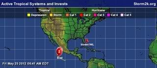
Here is a view of the low (Invest 94L) that very well may become TS Beryl and bring rain to Florida as it takes a left turn. Heck, if it turns to the west, it'll bring rain to the state even if it doesn't develop into a tropical storm.Tropical Storm Beryl Likely To Develop On Saturday & Come Ashore In Northeast Florida Near Palm Coast & Saint Augustine On Sunday Night
Actually, Rob's forecast is worth posting here in it's entirety:
Friday, May 25, 2012 6:14 am
by Rob Lightbown
Invest 94-L, which is a broad area of low pressure currently located just north of Great Abaco and Grand Bahama Island in the northwestern Bahamas is currently tracking north-northeastward this morning. Currently, environmental conditions are not very favorable for additional development with very strong shear over this system. This was expected as I still do not expect this system to really get going until Saturday. I fully believe that Invest 94-L will transform into a tropical storm during the day Saturday and be named Beryl during Saturday.
So, on Saturday a ridge of high pressure is expected to expand eastward into the southwestern Atlantic and put this system into an environment that is more favorable for development as it tracks to a position about 275 to 300 miles east of Jacksonville, Florida. This eastward building high pressure system will cause this storm to turn to the west and west-southwest by Saturday night and Sunday while it intensifies into a 60 to perhaps 65 mph tropical storm. I still think it is likely that Beryl to be will come ashore in northeastern Florida very near Palm Coast and Saint Augustine on Sunday night as a 50 to 60 mph tropical storm.
Once onshore in northeast Florida I think we will see Beryl first track westward into northern Florida during Monday and into Monday evening before pulling out to the northeast near the Georgia, South Carolina and North Carolina coast on Tuesday and Wednesday where it may redevelop and strengthen. By Thursday, I think we will see Beryl track to the south and east of southern New England and into the open Atlantic by next Friday.
My thinking is fully supported by most of the model guidance, including the European model which I am following quite closely.
As for actual weather associated with Beryl to be: Heavy rainfall with flooding and gusty winds to 40 to 50 mph in gusts are likely today across the northwestern Bahamas.
On Saturday, heavy rainfall with winds to tropical storm force are likely along the entire South Carolina coastline as well as across southeastern and eastern North Carolina.
On Saturday night and Sunday, heavy rainfall with tropical storm force winds with gusts to 50 to 60 mph are possible along the entire Georgia coastline as well as across northeastern Florida, including Jacksonville, Saint Augustine and Palm Coast. Heavy rainfall and tropical storm force winds will continue into Sunday night across northeast Florida as Beryl comes ashore. Heavy rain with gusty winds are likely on Monday across all of northern Florida as Beryl comes further inland across northern Florida.
Beach-goers and vacationers along the coast from northeastern Florida northward to the Georgia, South Carolina and southeastern & eastern North Carolina coastline should be advised that squalls of heavy rain along with tropical storm force winds up to 60 mph and very rough surf are likely throughout the Memorial Day weekend.
35/34.5/26 24/22/1/1
I finally found Cow Creek. It's at the end of the Road to Nowhere!
I finally found Cow Creek. It's at the end of the Road to Nowhere!
Re: Tropical weather update for the long weekend
so here is my ? can we fish monday or not?
Re: Tropical weather update for the long weekend
Don't ask me! We likely will just get some needed rain in west central FL. But they still are not sure what this thing is going to do. Some think it will come in farther south. Others think it will come into GA.bassboy wrote:so here is my ? can we fish monday or not?
Latest news below. See my caps at the end.
From 8:05 PM EDT discussion of Special Feature.
...SPECIAL FEATURES...
A BROAD AREA OF LOW PRESSURE CONTINUES TO IMPACT PORTIONS OF THE
W ATLC AND NW CARIBBEAN. CURRENTLY A 1009 MB LOW IS CENTERED
NEAR 31N75W WITH A TROUGH AXIS EXTENDING THROUGH THE LOW CENTER
TO THE STRAITS OF FLORIDA NEAR 24N80W. AN UPPER LEVEL TROUGH
EXTENDS DOWN THE ERN SEABOARD TO THE NW CARIBBEAN PRODUCING A
LARGE AREA OF UPPER LEVEL DIFFLUENCE E OF THE SURFACE TROUGH
AXIS. THIS PATTERN IS SUPPORTING STRONG SHOWERS AND
THUNDERSTORMS E OF THE SURFACE TROUGH AXIS ALONG A 180 NM WIDE
SWATH FROM 32N71W TO THE CENTRAL BAHAMAS AT 25N77W TO CENTRAL
CUBA AT 22N79W. SHOWERS CONTINUE N OF 32N AND WRAP AROUND THE N
SIDE OF THE LOW CENTER. HEAVY SHOWERS HAVE BEEN OVER CENTRAL
CUBA AND THE BAHAMAS FOR MORE THAN 24 HOURS. REPORTS FROM
CENTRAL CUBA INDICATE RAINFALL TOTALS RANGING FROM 6-20 INCHES
WHICH HAVE CONTRIBUTED TO FLOODING AND MUDSLIDES. HEAVY RAIN
CONTINUES TO FALL ACROSS THIS AREA. FREEPORT BAHAMAS REPORTED A
24-HOUR TOTAL OF 9.7 INCHES. A RECENT SCATTEROMETER PASS
INDICATES STRONG WINDS UP TO NEAR GALE FORCE WINDS ARE E OF THE
TROUGH AXIS. WHILE THE LOW CENTER IS NOT WELL DEFINED AT THIS
TIME...UPPER LEVEL CONDITIONS ARE CONDUCIVE FOR DEVELOPMENT OVER
THE NEXT 48 HOURS. THERE IS A HIGH CHANCE OF THE SYSTEM
DEVELOPING INTO A TROPICAL CYCLONE OVER THIS TIME PERIOD.
INTERESTS IN THE SE UNITED STATES COAST SHOULD MONITOR THE
PROGRESS OF THE SYSTEM.
35/34.5/26 24/22/1/1
I finally found Cow Creek. It's at the end of the Road to Nowhere!
I finally found Cow Creek. It's at the end of the Road to Nowhere!
Re: Tropical weather update for the long weekend
Latest from the Nat'l Hurricane Center. Bolding is mine.
SPECIAL TROPICAL WEATHER OUTLOOK
NWS NATIONAL HURRICANE CENTER MIAMI FL
845 PM EDT FRI MAY 25 2012
FOR THE NORTH ATLANTIC...CARIBBEAN SEA AND THE GULF OF MEXICO...
SATELLITE PICTURES AND REPORTS FROM NOAA BUOY 41002 INDICATE THAT
THE LOW PRESSURE AREA...CENTERED ABOUT 300 MILES EAST OF CHARLESTON
SOUTH CAROLINA...IS BECOMING BETTER DEFINED AND HAS DEVELOPED
THUNDERSTORM ACTIVITY NEAR THE CENTER. IF CURRENT TRENDS
CONTINUE...ADVISORIES COULD BE INITIATED LATER TONIGHT. THIS SYSTEM
HAS A HIGH CHANCE...NEAR 100 PERCENT...OF BECOMING A SUBTROPICAL OR
TROPICAL CYCLONE DURING THE NEXT 48 HOURS. LITTLE MOTION IS
EXPECTED TONIGHT...BUT A WEST-SOUTHWESTWARD OR SOUTHWESTWARD MOTION
SHOULD BEGIN TOMORROW AND CONTINUE THROUGH SUNDAY. COASTAL
INTERESTS FROM THE CAROLINAS SOUTHWARD THROUGH NORTHEASTERN FLORIDA
SHOULD MONITOR THE PROGRESS OF THIS SYSTEM OVER THE MEMORIAL DAY
WEEKEND. IN ADDITION...LOCALLY HEAVY RAINFALL AND FLOODING WILL
CONTINUE THROUGH AT LEAST TONIGHT OVER PORTIONS OF CENTRAL CUBA AND
THE CENTRAL BAHAMAS. FOR ADDITIONAL INFORMATION ON THIS
SYSTEM...PLEASE SEE HIGH SEAS FORECASTS ISSUED BY THE NATIONAL
WEATHER SERVICE...AND PRODUCTS FROM YOUR LOCAL WEATHER OFFICE.
ELSEWHERE...TROPICAL CYCLONE FORMATION IS NOT EXPECTED DURING THE
NEXT 48 HOURS.
35/34.5/26 24/22/1/1
I finally found Cow Creek. It's at the end of the Road to Nowhere!
I finally found Cow Creek. It's at the end of the Road to Nowhere!
-
mauso1
- Supporter 2007 - 2013
- Posts: 5390
- Joined: Wed Dec 31, 1969 7:00 pm
- Location: whoo hoo back on the water
Re: Tropical weather update for the long weekend
Am I wrong or is Beryl heading away from us and out into the Atlantic ?

Source TBO..dang I was hoping for rain..can't fish anyway
Source TBO..dang I was hoping for rain..can't fish anyway
Senior Exalted Pro Staff Member of the Paddle-Fishing.com Kayak & Canoe Anglers Club
Re: Tropical weather update for the long weekend
Sub-tropical Storm Beryl is supposed to head WSW toward the FL/GA border or southern GA. It should bring central FL a lot of rain on Monday. (That's according to Bay News 9.)
Here is the 5 am Discussion from the NHC:
Here is the 5 am Discussion from the NHC:
the center of Beryl is exposed about 90 nm east of the remaining
deep convection. Overall...cloud tops have warmed over the past few
hours as the convection has moved away from the center. However...
satellite classification remain subtropical 2.5 from both TAFB and
SAB...and the initial intensity will be kept at 40 kt. Beryl is
still entangled with an upper-level low...and water vapor imagery
shows dry air wrapping into the circulation from the south and
east. Given these factors...only slight strengthening is expected
during the next day or so. If convection is able to persist near
the center...it could lift the tropopause and erode the upper-level
low...allowing Beryl to transition to more of a tropical structure
before landfall as seen in fields from the global models. After
landfall...Beryl is expected to weaken to depression status...with
some slight strengthening possible after the center emerges back
over water. The NHC forecast is similar to the previous one and
follows a blend of the decay-SHIPS and lgem models.
Overnight the center of Beryl has slowed...and the initial motion
estimate is 255/04. As ridging builds north of the cyclone over the
weekend...Beryl should accelerate toward the west-southwest or
southwest today...and turn westward as the center approaches the
coast on Sunday. For the first 24 hours the new NHC forecast is an
update of the previous one...and from 24 to 48 hours the NHC track
has been shifted a bit to the right toward the new tvca multi-model
consensus. After 48 hours...the spread in the track guidance
increases regarding how far inland Beryl will move and how quickly
it accelerates northeastward ahead of a mid-latitude trough moving
into the eastern United States. Some of the model spread appears to
be due to differences in how much Beryl weakens as it moves
inland...as a shallower weaker cyclone will not be picked up as
quickly ahead of the trough. The GFS and GFS ensemble mean show
more westward progress...more weakening...and are slowest with the
northeastward motion. At the other extreme...the ECMWF does not
move Beryl as far inland...maintains a deeper cyclone...and
accelerates it northeastward much faster. Late in the period the
NHC forecast is between these two scenarios but remains slower than
the tvca consensus and near the right side of the guidance
envelope.
The initial 34-kt wind radii were adjusted inward based on a 0226
UTC ascat pass.
Forecast positions and Max winds
init 26/0900z 32.3n 75.6w 40 kt 45 mph
12h 26/1800z 31.8n 76.4w 40 kt 45 mph
24h 27/0600z 31.0n 78.1w 45 kt 50 mph
36h 27/1800z 30.6n 80.0w 45 kt 50 mph
48h 28/0600z 30.6n 81.6w 40 kt 45 mph...inland
72h 29/0600z 31.0n 83.0w 30 kt 35 mph...inland
96h 30/0600z 32.0n 80.5w 30 kt 35 mph...over water
120h 31/0600z 34.5n 75.5w 35 kt 40 mph
35/34.5/26 24/22/1/1
I finally found Cow Creek. It's at the end of the Road to Nowhere!
I finally found Cow Creek. It's at the end of the Road to Nowhere!
Re: Tropical weather update for the long weekend
Beryl has made the turn to the SW.
35/34.5/26 24/22/1/1
I finally found Cow Creek. It's at the end of the Road to Nowhere!
I finally found Cow Creek. It's at the end of the Road to Nowhere!
Re: Tropical weather update for the long weekend
BULLETIN
SUBTROPICAL STORM BERYL INTERMEDIATE ADVISORY NUMBER 4A
NWS NATIONAL HURRICANE CENTER MIAMI FL AL022012
800 PM EDT SAT MAY 26 2012
...HURRICANE HUNTERS FIND THAT BERYL IS A LITTLE STRONGER...
SUMMARY OF 800 PM EDT...0000 UTC...INFORMATION
----------------------------------------------
LOCATION...31.1N 76.9W
ABOUT 220 MI...350 KM SE OF CHARLESTON SOUTH CAROLINA
ABOUT 290 MI...465 KM E OF JACKSONVILLE FLORIDA
MAXIMUM SUSTAINED WINDS...50 MPH...80 KM/H
PRESENT MOVEMENT...SW OR 235 DEGREES AT 6 MPH...9 KM/H
MINIMUM CENTRAL PRESSURE...998 MB...29.47 INCHES
35/34.5/26 24/22/1/1
I finally found Cow Creek. It's at the end of the Road to Nowhere!
I finally found Cow Creek. It's at the end of the Road to Nowhere!
Re: Tropical weather update for the long weekend
Here are some key points from the 5 a.m. Discussion from the NHC:
Beryl still has the characteristics of a subtropical cyclone..... The initial intensity remains 45 kt
....cyclone has less than 12 hours before it will be approaching the
cooler shelf waters...the NHC forecast shows no change in intensity
prior to landfall. Beryl will weaken to a depression by 36 hours as
it moves slowly inland. Some restrengthening is expected when the
center moves back over water after 72 hours and additional
intensification is forecast as Beryl becomes extratropical by the
end of the forecast period.
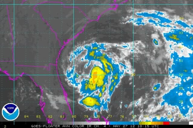
Below is a satellite view from a few hours ago. Our friends in Jax and surrounds could sure use the rain. As Beryl stalls, it's supposed to grow in size of the rain area.
Beryl still has the characteristics of a subtropical cyclone..... The initial intensity remains 45 kt
....cyclone has less than 12 hours before it will be approaching the
cooler shelf waters...the NHC forecast shows no change in intensity
prior to landfall. Beryl will weaken to a depression by 36 hours as
it moves slowly inland. Some restrengthening is expected when the
center moves back over water after 72 hours and additional
intensification is forecast as Beryl becomes extratropical by the
end of the forecast period.
Below is a satellite view from a few hours ago. Our friends in Jax and surrounds could sure use the rain. As Beryl stalls, it's supposed to grow in size of the rain area.
35/34.5/26 24/22/1/1
I finally found Cow Creek. It's at the end of the Road to Nowhere!
I finally found Cow Creek. It's at the end of the Road to Nowhere!

Re: Tropical weather update for the long weekend
So what's it mean for us?
Senior Exalted Pro Staff Member of the Paddle-Fishing.com Kayak & Canoe Anglers Club
"SANCTUARY!!!"
Capitalization is the difference between helping your Uncle Jack off a horse, and helping your uncle jack off a horse.
"SANCTUARY!!!"
Capitalization is the difference between helping your Uncle Jack off a horse, and helping your uncle jack off a horse.
Re: Tropical weather update for the long weekend
it means get your gear ready for tomorrow because Bill and I are fishing

Re: Tropical weather update for the long weekend
DaveR -- It means an increase in rain chances for west central FLA tomorrow.
Beryl stronger...now a tropical storm...
summary of 200 PM EDT...1800 UTC...information
----------------------------------------------
location...30.1n 79.9w
about 110 mi...175 km E of Jacksonville Florida
about 120 mi...195 km se of Brunswick Georgia
maximum sustained winds...65 mph...100 km/h
present movement...W or 265 degrees at 10 mph...17 km/h
minimum central pressure...997 mb...29.44 inches
35/34.5/26 24/22/1/1
I finally found Cow Creek. It's at the end of the Road to Nowhere!
I finally found Cow Creek. It's at the end of the Road to Nowhere!
Re: Tropical weather update for the long weekend
Beryl made landfall around Jax Beach just after mid-night with scattered power-outages and damage in the area. I saw a tornado warning for western Manatee over to SW Hardee from several hours ago and can still see that squall line on the radar and the lightning from my house in Lakeland.
I have to laugh at the Tampa area forecast for today from local meteorologist D. Phillips: "Bottom line, this is NOT our storm. Monday will bring a mixture of clouds and sunshine. Many areas won't see anything more than scattered showers and storms. Some folks will get NO rain. North of Gainesville will see several inches of rain. Not us."
And a dueling forecast from Channel 8: "...We will see some outer rain bands from this system throughout the day. Our rain chance is 60%. Heavy rain and gusty winds are possible with these storms. It will be steamy with high humidity and highs in the upper 80s."
Take your pick, but stay safe. What a weird start to the tropical season: early tropical cyclones and landfall into Jax. Go figure.
35/34.5/26 24/22/1/1
I finally found Cow Creek. It's at the end of the Road to Nowhere!
I finally found Cow Creek. It's at the end of the Road to Nowhere!
Re: Tropical weather update for the long weekend
Which means we wont get any rain at all until later tonight if we r lucky and it will be a quickie. Ihave learned not to trust our meteorologists at all because it seems they r 75% wrong most of the time. We have been told for days by them that we would get hit with a lot of rain i predicted to my wife and a few others that it would get as far as orlando and then turn and go somewhere else it always happens am i saying we wont get hit unless it a big one no because i dont want that but please we all need rain. Plus we couldve fished today as my daughter would say " Im just sayin"